The inter-workings of different cloud types have always been fascinating to me. The thermodynamics processes going on in the atmosphere can create a wispy cirrus cloud, or a happy cumulus cloud, or a scary wall cloud. There were some pretty cool clouds across the skies of central Kentucky ahead of Friday night’s mesoscale convective system (MCS). We received pictures of shelf clouds as the severe storms barreled in and undulatus asperatus clouds that appeared while the complex of severe storms was still 100 or so miles away.
Shelf Cloud
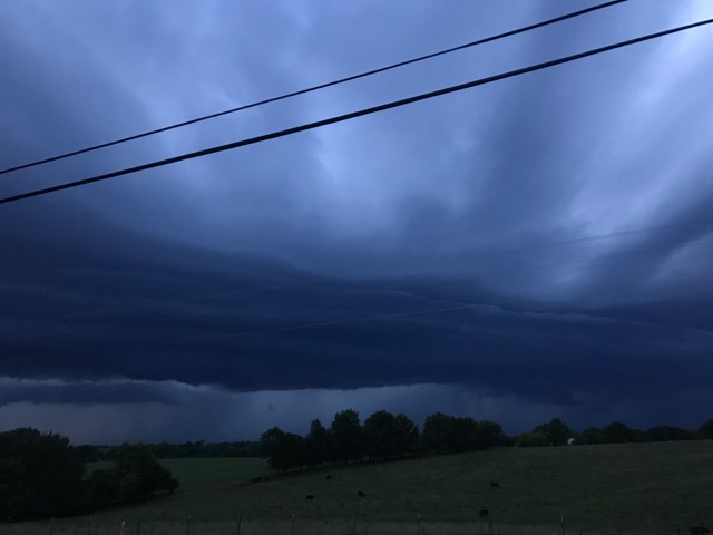
Shelf clouds are one of the top weather photo subjects that we receive. They can look like an alien spaceship. Shelf clouds form along the leading edge of a line of thunderstorms that will be capable of producing damaging winds. What you’re seeing is the boundary between a downdraft and updraft of a thunderstorm (the sinking and rising air within the storm.)
As the shelf cloud passes, you will feel an abrupt increase in wind speed quickly followed by heavy rain or possibly hail. The strongest wind gusts reside just behind the shelf cloud.

Undulatus Asperatus

These are an interesting cloud type. Undulatus asperatus is a relatively new cloud; they were only officially classified in 2017. This cloud type forms near or in the wake of thunderstorms.The sky resembles waves in a choppy sea. Undulatus asperatus are easily mistaken for mammatus clouds. The pouch-like mammatus forms on the underside of an intense thunderstorm as cool air begins to pool. Meanwhile undulatus asperatus form before convective activity gets started.
There are two main theories on how undulatus asperatus clouds form. One is that they may indeed be a distant cloud cousin of the mammtus. The other, more likely cause, is from gravity waves. We must remember that the atmosphere is a fluid, and all properties of fluids also apply to the atmosphere. It is possible to have waves and eddies in the air. The kinks can present themselves in the shape and appearance of the clouds.

Kelvin-Helmholtz
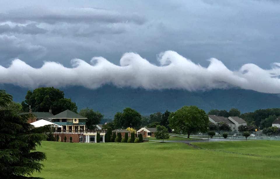
This next cloud type was not seen in Kentucky this week, but you may have seen this photo floating around your social media pages. Kelvin-Helmholtz clouds look like crashing ocean waves across the sky. These are a type of instability clouds that form due to variations in air density between different layers, resulting in differences in wind speeds. These clouds are extremely short-lived. They break just like a wave on a shore – the bottom layer moves slower than the top layer. This is why the top of the cloud billows over and crashes.
