

As the year, and decade, draws to a close it is time for all of those Top 10 lists. NOAA recently compiled a list of some of the best satellite images of the past year. 2019 was a year of record-breaking tropical cyclones—in both the Atlantic and the Pacific. Wildfires ravaged many parts of the world. And astronomical events were on full display. The GOES-17 became operational this year. This is the latest in a new fleet of satellites. The GOES-17 satellite has already delivered critical data and imagery of the eastern and central Pacific Ocean and areas as far away as New Zealand. This new generation satellite has also enhanced forecast capabilities for the western US, Alaska, and Hawaii.
This new technology gives us a dazzling view from up top of our planet. I know I'm a weather nerd, but I could look at these images on a loop for an entire afternoon. The detail is remarkable! Without further ado, in no particular order, here is the Top 10 satellite images of 2019.
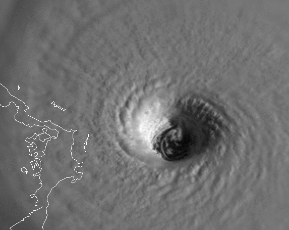
1. The eye of Hurricane Dorian
In early September, Hurricane Dorian devastated the Bahamas, especially Abaco Island. Dorian was the first major hurricane of the Atlantic hurricane season, and later became one of the most powerful hurricanes in the Atlantic basin. Before making landfall the storm strengthened to a Category 5 with maximum sustained winds of 185 mph. After landfall Dorian stalled over Abaco for close to 24 hours as a powerful Category 5 hurricane. GOES-16, which covers the Atlantic Ocean, captured the eye of Dorian approaching Abaco Island.
2. Southern Hemisphere storminess
Also in early September, the GOES-16's Red-Green-Blue Air Mass band snapped images of several low pressure centers swirling off the coast of Chile. The different colors reflect the clash of different airmasses that generated the low pressure systems. You may notice everything is spinning clockwise, and think but I thought low pressure spun counter-clockwise. In the Southern Hemisphere circulations are flipped from what we experience on the other side of the Equator.

3. Southwestern storm
Another brilliant display of a spinning cut-off low, this time closer to home. Before Thanksgiving a low moved through the southwestern US. The GOES-17 Day Cloud Phase Distinction feature generated some neat imagery.

4. Large plume of Saharian dust
Visible satellite imagery is literally a snapshot from space. GOES-16 captured one of the largest plume of dust from the Saharian Desert of the year in November. The wind blew this plume west across the Atlantic.

5. California wildfires
It was another year of devastating wildfires in California. The plume of smoke from the Kincade Fire stretched from hundreds of miles on GOES-17 imagery.

6. Fires Down Under
Wildfires also raged in Australia. Japan's Himawari-8 satellite captured heat signatures and smoke plumes from bushfires in the New South Wales.

7. Total solar eclipse
In July the Southern Hemisphere was treated to a total solar eclipse. Visible satellite imagery displayed the Moon's shadow.

8. Moon flyby
The GOES fleet of satellites doesn't just monitor events on Earth. The Solar Ultraviolet Imager can also observe events on the Sun. The image below is from February when the Moon passed in front of the Sun.

9. Solar flare
Along with tracking events on the surface of the Sun, the Solar Ultraviolet Imager is helping to improved space weather forecasting. One of those ways is there advanced detection of solar flares, such as this one from March.

10. Riakoke volcano eruption
GOES-17 spotted the ash cloud following the eruption of the Riakoke volcano in Russia.

