Winter isn’t coming, it is here! The past two days have brought us our first taste of wintry precipitation. The first winter weather advisories of the season were issued, and we elevated the Threat Index for the first time because of tricky road conditions. Before the next round of winter weather arrives, here’s a refresher of the LEX 18 StormTracker Threat Index.

The Threat Index is parked at zero most days of the year. These are normal weather days. But during the winter these “normal weather days” we may track flurries or light snow with little to no accumulation expected, very minor travel impacts, or bitterly cold temperatures.
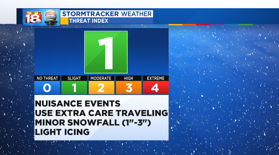
This first winter event of the season was warranted a Threat Level 1. These are nuisance events that you need to use extra care while traveling. Snowfall and icing amounts are minor, generally less than three inches for snow and less than quarter of an inch for freezing rain. Days with winter weather advisories fall in this category.

A Threat Level 2 is for winter events that could impact live and property. Sporadic power outages brought on by moderate ice storms may occur. Under half a foot of snow is expected on these wintry days. We were at a Level 2 last February when we experienced up that big, heavy, wet snowfall.

“Big deal winter weather events” get a Threat Level 3. We will track significant ice and snow on these days. Think the big recent snows of January 2016 and March 2015. You will likely be snowed in for a few days. Widespread power outages are expected.

Like with severe weather, we reserve a Level 4 for the most extreme winter weather days. The February 2015 blizzard and Lexington’s historic ice storms in 1994 and 2003 would have fit in this category.
