For most of the year we’ve been telling you how wet we’ve been. And for the past few months, Lexington’s total precipitation has been creeping closer and closer to the wettest on record. This weekend the seven-year-old record will likely fall.

Our year-to-date precipitation total sits at 65.61″. It’s less than three-quarters of an inch to go to reach the top spot. Here’s some more rainy facts. Our rainfall surplus for the year is 24.50″. (Lexington’s average annual precipitation is 45.17″.) If it doesn’t rain a drop or a flake doesn’t fly between now and June 7, 2019, then we would be back to “normal.” That’s half a year’s worth of rainfall!

We are tracking rain to come in two main waves over the next two days. A warm front will push northward this evening, ushering in periods of showers overnight. Widespread rain will taper off into the afternoon for the Bluegrass. Meanwhile down south, scattered showers will continue as the next system nudges eastward.

Again, we will be on the “warm” side of this approaching system, which will be a big snow producer for the northern Plains this weekend. The second warm front in as many days will track northward Friday night. This will put central Kentucky is the warm sector. Not only will more rain move in, but it will be unseasonably warm and windy as we kick off December. This second round will feature the potential for gusty thundershowers Saturday afternoon. All the wet weather will shut down late Saturday night/early Sunday.
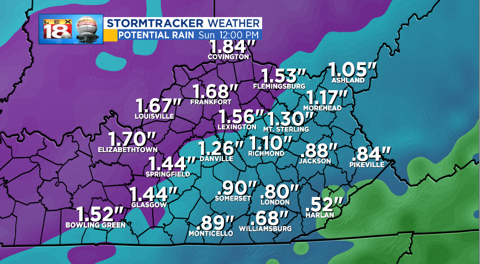
One to two inches of rain are expected through early Sunday afternoon. A corridor of higher rainfall amounts will run from Lexington and points north and northwest. (Lower totals are expected across southeastern counties.) Again, we only need three-quarters of an inch of precipitation to tie the yearly record. After this weekend’s rainfall, the record will likely be squashed.
