Here we go! The wintry precipitation is tracking into southern Kentucky. The swath of snow, sleet, freezing rain, and cold rain will continue pushing northward overnight. From here on out who sees wintry weather and who doesn’t will come down to location.

There still looks to be a sharp cut-off across the Bluegrass. Areas to the north won’t see anything. Some will see a little bit. And others will see more significant snow and sleet accumulations. The line is likely to be drawn near I-64. We have multiple threat indices given all the different scenarios around central and eastern Kentucky.

North of I-64 remains at a zero. There will be very little, if an impact from this storm. A larger area south of I-64 is at a Level 1. A wintry mix will be possible along with a minor snow/sleet accumulation. Threat Level 2 is for the far southeast corner of Kentucky. Several inches of heavy wet snow are expected to fall, which will put stress of power lines and tree limbs.
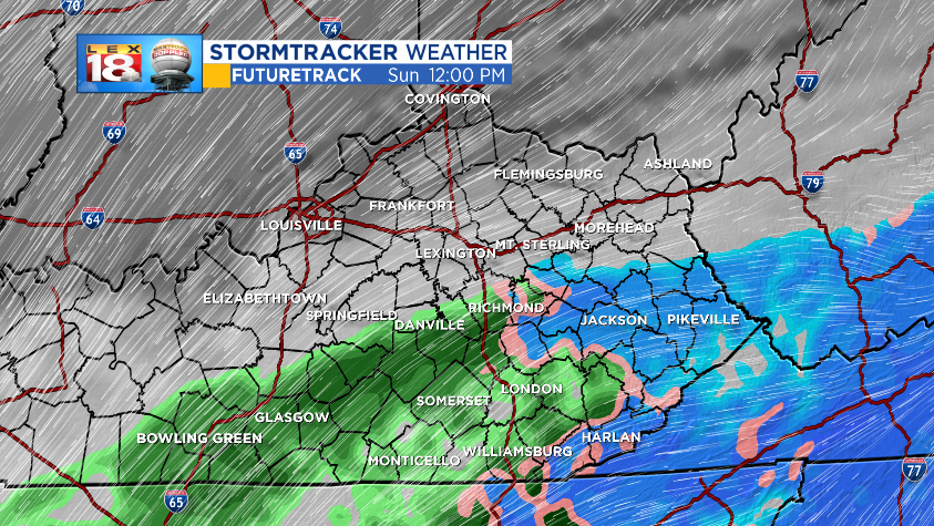
All precipitation types are on the table from start to finish. It will be mostly snow, sleet, and freezing rain tonight. There may be some periods of cold rain mixing in on Sunday. Futuretrack pull the swath of wintry precipitation as far north as Danville and the Mountain Parkway. East of I-75 stays cold enough for all snow, a heavy, wet snow.
We are tracking the wintry precipitation to rapidly shut down Sunday afternoon from west to east. Most of activity will have exited the Commonwealth by Sunday evening. The next concern will be for re-freezing Sunday night as temperature fall into the lower 20s.

The battle line still fluctuating. There has been a little more of a northwest trend over the last few model runs. While our latest snowfall forecast keeps Lexington in the clear, Danville and Richmond could see a wintry mix and less than an inch of snow. Twenty to thirty miles could make the difference between snow and a minor accumulation.
So the bottom line is southern Kentucky will be at the greatest threat for a heavy wet snow and wintry mix. Accumulations will drop off farther north before reaching the cut-off point. Far northern Kentucky will see no impact from this storm. A change in the track could bring some of the wintry mix into Lexington Sunday afternoon.
