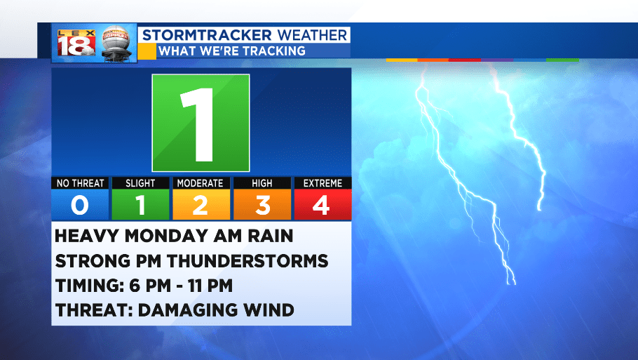
It’s been a wet and wild 2018, so it’s only fitting that Mother Nature sends all she has left in the tank before we end 2018. We’re expecting everything from rain to wind, to storms as we are prepping for the ball drop.

The rain will begin early tomorrow morning for southern and western counties. A warm front lifting north will bring in a swath of moderate to heavy rain showers. This will last through mid-morning. Some of the heavier rain showers may reduce visibility on roads.

The middle of the day will likely be the only break that we get from the two frontal events. This isn’t to say that rain won’t be around in the middle of the day, but chances drop for a little but. It will be short-lived however.

A line of strong rain and thunderstorms will march eastward as the cold front pushes that way as well. The squall line will bring the best chance for damaging wind gusts for tomorrow.

The squall line will pass the Bluegrass through the dinner time hours New Year’s Eve. The line will continue eastward and bring storms to the eastern counties before we reach midnight. Storms will lose strength as they pass the I-75 corridor.

Rain amounts will range between 1” to 2” collectively. Higher amounts to 3” are possible under the strongest of storms. Widespread flooding is not expected at this time, but there will likely be some isolated locations that experience high water. Remember to NEVER drive through a flooded roadway.

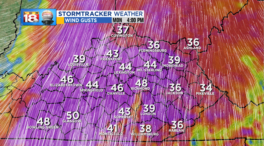
The main threat will be the potential for damaging wind gusts as the thunderstorm line passes in the evening. Widespread wind gusts will reach 40-50 mph out of the south and southwest before the front passes. West-east oriented roads will feel the strongest cross winds making driving difficult.

In the evening, as the front passes, winds will combine with thunderstorms and can produce stronger gusts. Wind gusts could top out in the 50-60 mph range.
Due to the chance for severe weather tomorrow night, our StormTracker Severe Threat Index will be elevated to a ONE or SLIGHT through the event.
Also, don’t forget to download the FREE StormTracker Weather App for your smart device to have all the latest weather information in the palm of your hands. Keep it with the LEX 18 StormTracker Weather Team for all of the latest information and updates with the New Year’s Eve Storm. LEX 18 StormTracker Page.

