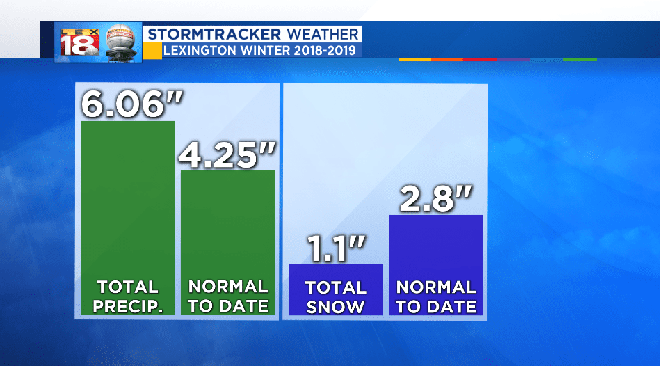
I don’t know about you, but I like my winter to be white not muddy. Since December 1st, the start of meteorological winter, Lexington has recorded over six inches of total precipitation. That’s around two inches above-normal. Meanwhile our snowfall total sits at 1.1 inches. Most of that snow fell in November; only a tenth of an inch was recorded in December.
The muddy trend continues here in the new year. Fresh off the wettest year on record, more rain tracks in this afternoon as a low crosses the Commonwealth. A warm front is guiding the initial push of showers into southern Kentucky this morning. Activity will continue to spread northward with widespread rain hanging around through very early Saturday. A rumble of thunder and heavy rain will be possible as the low passes overhead this evening.

Rain will quickly wrap up from west to east Saturday morning as the low departs to the east and turns into a Nor’easter for New England. Up to an inch of rain will be possible. Most of the rain will fall this evening. This will be the first rainfall of 2019, and continues the muddy and wet trend of the past twelve months.

The weekend will bring us some time to dry out. Sunshine will return and temperatures will be on the way up. We are tracking a big January warm-up with highs trending towards 60° to start the new week. Our next round of wet weather will arrive late Monday.
