The weekend is almost here, and so is a winter storm. There will be a potpourri of wintry conditions over the next two days. And it will all come down to where you live. Some will see almost exclusively snow, for others it will be mostly a cold rain, and more could see a mix of both. There are a number of scenarios so let’s break them all down.
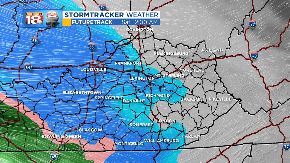
Things get started after midnight as snow for everyone. We are tracking snow to overspread the area by the time you wake up on Saturday. This is going to be a heavy, wet snow. Travel may become difficult with slick road conditions and reduced visibility. A Winter Weather Advisory has been issued for almost all of the LEX 18 News viewing area (southern and southeastern counties are not included.) Slushy snow accumulations will be possible through lunchtime.

Starting mid-day some “warmer” air will lift northward towards I-64. Snow will start changing over to a cold rain. High temperatures will only manage the mid 30s Saturday, so that rain is going to make things pretty miserable. It will also melt some of the snow from earlier in the day. Meanwhile for northern Kentucky the cold air will stand firm. We are tracking almost all snow north of I-64.

Temperatures will just need to drop a few degrees Saturday night to turn the precipitation back to snow. There may be periods Saturday night and early Sunday where we see more snow than rain, especially across the Bluegrass. Periods of rain and snow will continue Sunday before ending as scattered snow showers early Monday.
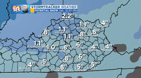
As mentioned above while accumulating snow is coming, it will melt away for some. *One* model shows the potential for one to two inches of snow by lunchtime on Saturday. Snow continues to accumulate near the Ohio River through the rest of the weekend. For the rest of central Kentucky, rain melts some of that snow away before a little more returns Saturday and Sunday night.
We are keeping the weekend snow total forecast the same as yesterday. Two to six inches are expected for northern Kentucky with the higher end of that range closer to Cincinnati. Most of use could receive one to three inches of snow over the course of the weekend. Areas near the Tennessee line will likely see less than an inch.
