A month’s worth of rain has already fallen. A whole lot more rain is coming through Saturday. The primary threat going forward will be for more heavy rain that could lead to flooding. A secondary threat with the strong storm potential will be for strong to even damaging wind gusts. The best timing for strong storms will come during the evening and at night.

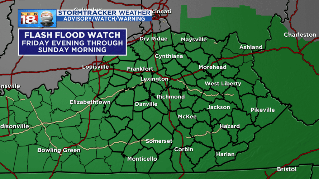
Let’s start with the biggest threat – heavy rain and flooding. A Flash Flood Watch goes into effect for all of central and eastern Kentucky this evening. There will be a lull later tonight before rain fills in and becomes heavier and steadier. Widespread rain will continue through mid-day Saturday.
Flooding is more likely to occur, and may occur quickly because the soil is so saturated. The ground is like a saturated sponge. If you try to pour more water over the sponge, the water just rolls right off of it. Heavy rainfall will lead to excessive runoff then ultimately more flooding. Those living near poor drainage and low-lying areas may need to be on alert. Streams, creeks, and rivers already running high and will continue to rise through this event.
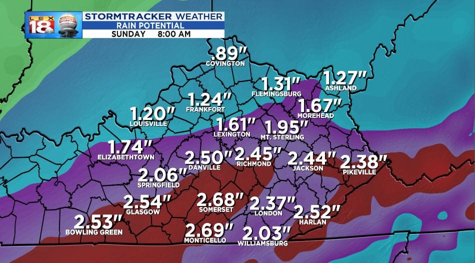
Southern Kentucky has been swamped with heavy rain already this week. The Lake Cumberland area into southeastern counties are expected to see the majority of the rain over the next day and a half. A general one to three inches are expected. Less to the north, more to the south. Locally higher amounts can’t be ruled out across south-central Kentucky.

There is also the potential for some gusty storms Saturday evening. Yesterday’s severe threat outlook for Saturday included an “enhanced” risk for western counties and a “slight” risk for the rest of central Kentucky. The enhanced and slight risk has been pulled back in the outlook update today. The reason – a reduced amount of instability, or fuel for storms. Storms will still be gusty and fast-moving, but they might not be as strong.

All of the ingredients will be present for strong, springtime storms. A warm front will move through early in the day. This will bring the widespread swath of rain during the morning. This boundary will also supply plenty of moisture, hence the continued heavy rain threat. The wind field will get cranked up between the warm and cold fronts tomorrow. There’s the shear. Wind gusts of at least 45 mph will be possible. Thunderstorms will develop along and ahead of the approaching cold front. If we see a little sunshine during the afternoon lull then the potential for severe thunderstorms will be greater. Sunshine would boost the instability in the atmosphere.
Severe or not, these storms will be fast-movers and carry with them a lot of heavy rain and windy. Our window for strong, gusty storms will be only a few hours. These windy conditions could more easily topple trees due to the waterlogged soil. We’ll have to watch out for that along with rising water levels through Saturday night.
All of the rain and storms will end quickly into the wee hours of Sunday. Temperatures will take a tumble and it will remain windy behind the potent cold front Sunday. This will also begin several dry days that will stretch through the end of the month.
