Spring has sprung. Well, at least for the weekend. Along with warm and windy conditions this afternoon, we are tracking the potential for rain and gusty thunderstorms. A strong storm system will bring everything from blowing heavy snow to severe thunderstorms across the middle of the country.

We will be on the warm, stormy side of this system. Portions of the Mississippi and Tennessee valleys, including far western Kentucky, will be the target area for severe weather today. We aren’t out of the woods. A few strong thunderstorms can’t be ruled out during the second half of the day. Areas west of Highway 127 are on the edge of the “slight” risk, while the rest of central Kentucky is outlined in the “marginal” risk of severe weather from the Storm Prediction Center.

Rain and storms will come in waves starting this afternoon. The first round will arrive as a warm front bubbles north. This initial batch will be mostly rain, which could be heavy at times, with a few rumbles of thunder. This will also be the time when the wind really kicks up with gusts between 35 and 40 mph, and temperatures take off. We are expecting highs in the 60s today!
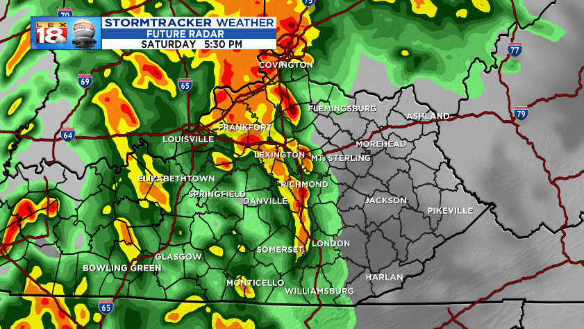
The window for some strong storms will open up once be are positioned in the warm sector, the area between the warm and cold fronts. The next wave arriving closer to dinnertime will be a better probability of including thunderstorms.
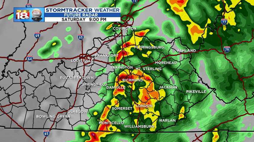
Heavy rain and strong storms will continue to cross the Bluegrass and move east through the evening. Thunderstorms will start to loose their punch going forward with time. The severe potential will diminish, but still a few strong storm may survive the journey into central Kentucky. Activity will weaken and exit eastern Kentucky around midnight.

Strong wind gusts and heavy rain will be the primary threat. Inside or outside of a thunderstorm, the wind will gust up to 45 mph later today. Three-quarters to over an inch of rain will be possible as these batches of storms march through the area. The threat for flooding is not quite as high as a few weeks ago. We have gotten some time to dry out, and the excess water has somewhere to go.
Stay with the StormTracker Weather Team for the latest weather updates throughout the day. You can get updates at LEX18.com, on Facebook and Twitter, or on the *free* LEX 18 StormTracker Weather app.
