Today got off to a roaring start with widespread showers, some heavy rain, and rumbles of thunder. Maybe you were awakened a little earlier than you would have liked for Sunday morning. This was just round #1 of rain and thunder of the day. We are bracing for a more potent round this afternoon through sun down.

We have been talking about today’s severe weather potential for a few days now. The morning update from the Storm Prediction Center places all of eastern Kentucky plus part of the Bluegrass, including Lexington, in the ENHANCED RISK for severe storms. The rest of the area is outlooked in the SLIGHT RISK. Whether you’re in the enhanced or slight risk area, you can’t let your guard down this afternoon. Given the quick clearing following this morning’s showers, storms may blossom quickly and rapidly intensify through the second half of the day.

Speaking of that clearing, there will be a lull in the action late this morning through 1 PM or so. Sunshine has broken through the clouds. This will do two things: one – allow temperatures to surge into the 70s, and two – destablize or re-charge the atmosphere. Our atmosphere already juicy; there’s plenty of moisture and dew points will continue to rise. The combination of warm temperatures and a few hours of sunshine will replenish instability, or storm fuel. All that is missing is a lifting mechanism. That will come as the cold front marches eastward.
High-resolution model outputs have been consistent with the opening of a window for storm re-development during the early afternoon for the I-75 corridor. Unlike this morning, activity will be scattered. Many of these storms will develop on their own then move east.

Damaging wind gusts are still the top threat. All other modes of severe weather are also on the table this afternoon through sunset. Remember a severe thunderstorm must produce at least one of the following: wind gusts stronger than 58 mph, hail at least one inch (quarter size) in diameter, or a tornado.
Today’s severe threat will diminish around 8 PM. Maybe a little earlier closer to I-75, a little later to the east.

It will be a windy afternoon even outside of any storms. A Wind Advisory is in effect for the entire area for wind gusts of 40 to 50 mph. The strong gusts may bring down limbs and branches, which could cause power outages. It would be best to secure any light-weight outdoor objects, including garbage cans and furniture.
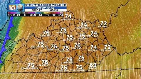
The cold front won’t just spark strong storms. It will also bring a sharp drop in temperature. We’ll surge into the 70s before storms get going this afternoon. Once the front crosses this afternoon temperatures will quickly drop into the 50s before settling into the upper 30s tonight. Needless to say it’s going to be a chilly start to the work week.
Stay weather aware this afternoon and evening. We will post regular updates at LEX18.com and on social media. You can also get the latest weather information on the LEX 18 StormTracker Weather app. It’s one-stop-shopping on a day like today. You can view the MaxTrack Live Doppler, any active weather alerts, future radar, and more on your favorite device. Oh, and it’s a free download!
