Let’s talk about something other than the rain, shall we. By now you’re probably sick of seeing daily chances for heavy rain and storms. Some areas, especially across southern Kentucky and the hills of eastern Kentucky, have been hit with multiple rounds of heavy rain and flooding. We’re over the hump and the end still near. What follow will be extra sweet.

A cut-off has been sitting and spinning across the southern U.S. for days now. It takes a strong system to get things moving with this split flow set-up. An approaching strong cold will do the job but in the process also spark additional rounds of scattered thundershowers Monday. The “strong” part of this cold front refers to the changes that it will bring to our forecast once it clear the Commonwealth. The severe threat will be low, however more torrential rain along with gusty winds will be possible. The final push will come during the afternoon then things will start drying out.
Much drier and more comfortable currently resides behind the front. Not only will showers come to an end, but skies will start to clear and it will feel a lot nicer. Tuesday is going to be awesome! Sunshine returns, it will be less humid, and highs will be in the mid 70s.

Your AC will catch a break this week. The cooler air mass will stick around all week. In week there will be another “layer of cool” coming behind a weak mid-week disturbance. (This system will bring chances for spotty showers late Wednesday through Thursday. The majority of the rain this go-around will be light.)
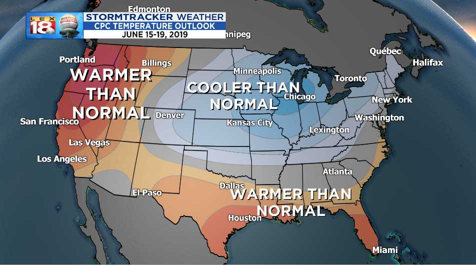
Long-range models are showing signs that this slice of spring is here to stay for a while. The 6-10 day temperature outlook from the Climate Prediction Center includes Kentucky in an area with a greater probability of seeing cooler than normal temperatures. Lexington’s average high temperature will be 83° to 84° by mid-June. This outlook doesn’t include how much cooler, just that chances are greater for below-normal temperatures. It will be nice to catch this break after having to crank the AC on full blast before Memorial Day.
