Happy Valentine’s Day! If you are heading out with your sweetie tonight, the forecast is looking good. Skies will remain cloudy, temperatures will be mild, and it will stay breezy. Rain showers are inbound after midnight.
Now if you’re delaying your valentine’s plans until tomorrow, we’re talking about a different story. An incoming storm system will bring wintry weather Friday evening through Saturday morning. Travel could be a little tricky as rain, snow, and a little ice move in.

This system will be passing to our south with colder air streaming in from the north. Northern and central Kentucky will see mostly snow. Areas south of the Cumberland and Hal Rogers Parkways will see more periods of freezing rain and a cold rain along with a little snow at the tail end.
As for timing, snow will begin to fall Friday evening. The best time for accumulating snow will begin during the late evening hours and continue through Saturday morning.
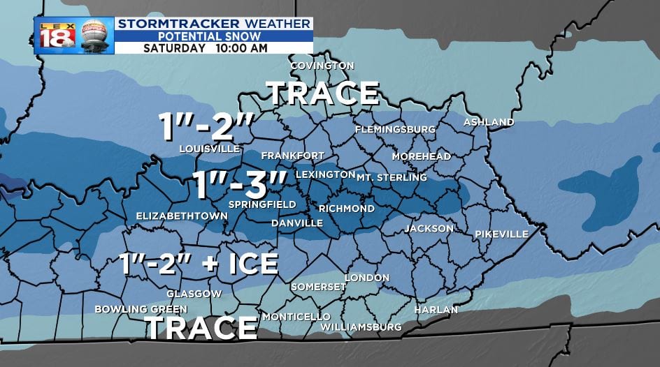
There will likely be a narrow band of one to three inches of snow, or mixed with sleet, near I-64. Areas to the north and south will see less. A glaze of ice will be possible for southern Kentucky.

A Winter Weather Advisory has been issued for the Bluegrass, down to Lake Cumberland, and to the west. Slippery road conditions could develop as snow falls Friday night.
Snow will wrap up rather quickly Saturday morning. Any snow on the ground won’t stick around for long. High temperatures over the weekend will be just above the freezing mark. A few more quick hits of rain and snow showers will be possible Sunday, then again Tuesday and Wednesday of next week.
