Rainfall continues in our extremely wet weather pattern. A broad area of light to moderate rain is sitting over the state with localized spots of heavy rain mixed in. Patchy fog is also reducing visibility at times. A FLASH FLOOD WATCH is in effect for today through tonight. Conditions will be right for rapid water rises through that time frame.
From yesterday’s rain we picked up anywhere from just shy of a half inch in Northern Kentucky all the way up to three and a quarter in southern counties. An additional 3″ to 4″ of rain is possible through the next four days. Due to this, flooding will be a threat moving forward. Flash flood and gradual flooding are both possible due to the large amounts of rain moving through. In addition to the swaths of rain, we’re also expecting embedded thunderstorms each afternoon. Strong storms are possible causing torrential rain and possible damaging wind gusts. Rain will continue through Thursday. After that, we should dry out for the weekend.

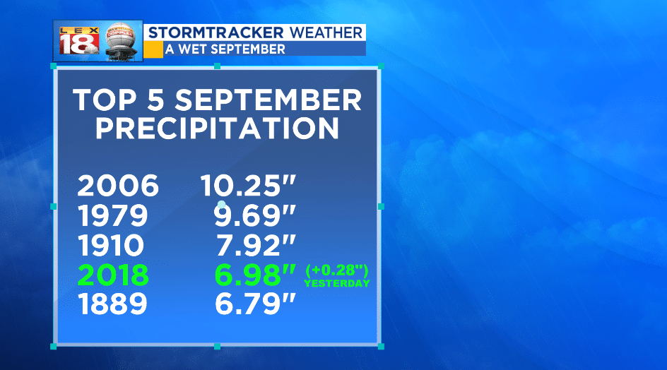
All of this rainfall allows us to continue climbing the record precipitation ladder. As of yesterday’s rainfall at the Blue Grass Airport (0.28″) 2018 is now fourth overall for the wettest September on record. We’re still expecting about 3″ to 4″ of rain through Thursday. We will be challenging the September record of 10.25″ if things go according to plan.