
Friday will be the end of ‘meteorological summer’. You’ll hear us talking about the meteorological seasons 4 times per year. Meteorological summer runs from June 1 to August 31. The rest of the seasons go in 3 month increments, so we’ll be talking about meteorological winter on December 1! There really is no weather reason why we have these, it’s really just for bookkeeping purposes. In our record books it’s just much easier to keep track of our ‘seasons’ ending on nice round numbers rather that having to look up at exactly what day the equinox or solstice occurs in any given year. It’s our world and our rules…so there 🙂 .
So with that preamble let’s look at the Summer of 2018. Keep in mind we have one more day to go, which is when you’ll likely be reading this as I don’t think many of you are sitting there chomping at the bit at LEX18.com for when this gets published around 10:00 Thursday evening. With that one more day there may be 1/10s of a degree movement in the temperature averages and we can add to the rain total on Friday if one of those forecasted scattered t-storms finds the offiical bucket at the Blue Grass Airport. But overall, the numbers are pretty good.
Summer 2018 will go in as a warm and wet one. Although how we get there temperaturewise is not necessarily how you’d think.

So let’s look at the numbers…first of all when you look at the average temperature 2018 will be a top 20 warm summer. It’s a pretty impressive stat, but let’s look at how we get there. It’s not from an extreme number of ‘hot’ days or even consistently hot days. Our average high for the summer was 86 which puts us at rather mundane 38th place (top side of average…or bottom side of above average). However when you look at the average low temperature coming in at 66.6° (evil foreshadowing?) that ranks us in the top 10! We’ve had a lot of warm muggy summer nights this year. For much of this summer our dew points have been in the 70 or so range. This is well into the ‘muggy’ range and pushing the really uncomfortable level. Temperature doesn’t drop below the dew, so that keeps our morning lows very warm running on average 3 to 4 degrees above normal. Keep in mind that our normal low is in the upper 50’s at the beginning of June and is back to the low 60’s now. So it wasn’t extreme heat that got us to the top 10, but lots of warm nights.
While we’re talking about extreme heat we did have a really hot day this year. The 4th of July topped out at 97 which is a number we don’t get to all that often. Only 33 years total have had temperatures hotter than that. What’s really interesting in the historical sense is how many of the years that were really hot occurred a long time ago. 18 of the years occurred before 1950 and 21 of the years before 1954…which means the early 50s were really hot around here in the summer. How about this and could you just imagine this…in 1936 there were 28…28 days…days hotter than 97…without air conditioning!
Now for the rainfall…
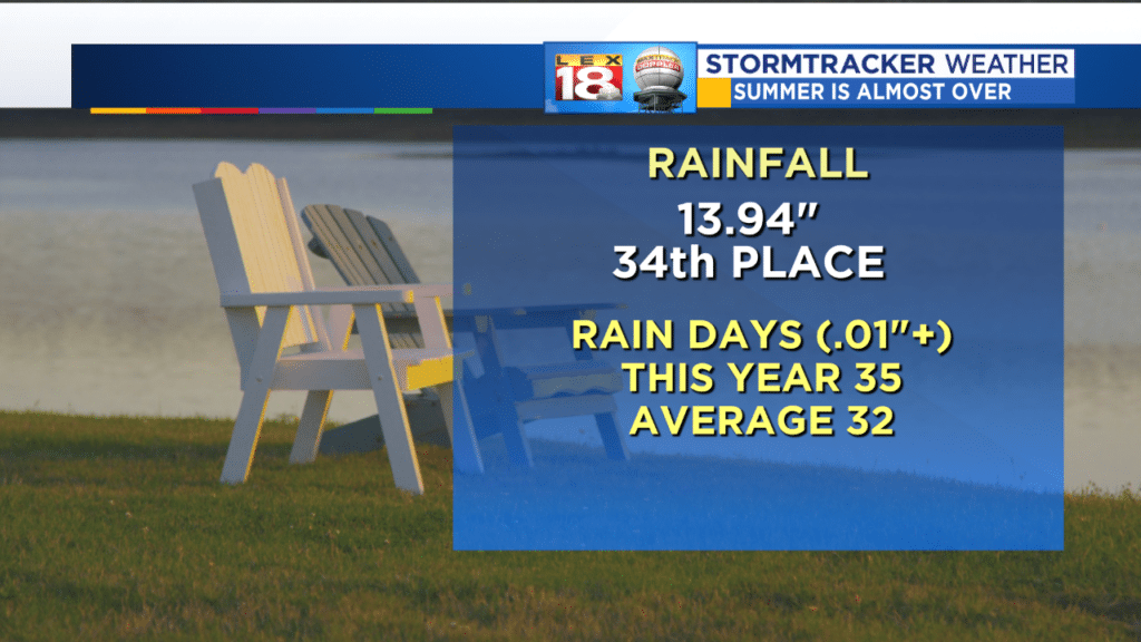
Here we are at the end of August and your grass is REALLY green. Rainfall has been plentiful and regular this year. June and July both were slightly below normal, but August has been above, and by enough to take us into at least 34th place (depending on if it rains at the airport Friday). The nearly 14 inches is going to put us at the low end of above normal. We haven’t gone more than 5 days without measureable rain since the middle of June…and why you never got a break from mowing.
It looks like the summer time heat and humidity will also be bleeding into September, through the holiday weekend and beyond. And why not, after all it’s still the ‘real’ summer (at least for 3 more weeks).
All the best to you and yours…
Bill
