
WOW…we’ve got small scale and huge scale wows to talk about. Let’s get the small stuff out of the way. If we didn’t have the potential for a major hurricane hitting Florida our weather changes this week would be a big deal.

A 30 degree drop from Sunday to Friday. It will be a shock to the system going from above normal for July to normal for the 2nd week of November. We discussed yesterday how Hurricane Michael is going to be the catalyst for that change.
So let’s talk about the huge and impactful weather story, Hurricane Michael. If you look at last night’s blog entry we talked about and showed how the computer modeling was taking Michael to major hurricane status. We were also talking how in rapidly developing systems the Hurricane Center sometimes plays catch up with intensity forecasts. Well they’ve caught up as they’re now forecasting a major hurricane hit in the category 3 range on the Florida panhandle.
At this point they have it as a Cat 3 around Panama City Wednesday afternoon. Hurricane Warnings are up from the Florida/Alabama line to Cross City which is north of Tampa. The forecasts of winds well into category 3 and perhaps pushing 4 is on the table. In addition a storm surge potential of a foot exists in parts of the panhandle. Also, torrential rainfall will occur, and some of that will be over the Carolinas that Florence hammered in September. This storm’s fast movement will also take the high wind potential well inland, so even places like Tallahassee could see significant damage. The hurricane warning runs all the way to south Georgia. You can get the latest from the National Hurricane Center.
The previous blog post showed the pressure from the European model and how it was advertising pressure down to around 950mb which equates to a mid to high end Cat 3 storm. The latest run this afternoon continues that, and in fact is slightly deeper.
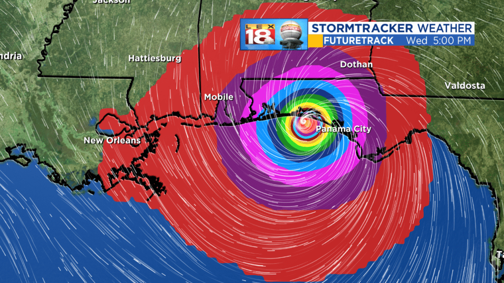
The circle of orange in the middle indicates central pressure between 944 and 948mb. This puts it at the cusp of category 4 in the model world. Hopefully reality won’t come to that full realization. The Euro model also takes direct aim at one of Kentucky’s favorite beach destinations, Destin.
The final strength and destination still remain in a degree of flux, but anyone along the Florida panhandle should heed any and all official warnings and statements and take appropriate action.
Also, the modeling has been giving Michael a sharp right turn before the Appalachians. If it’s slower to turn…and given the strength of the ridge we’ve been under it’s certainly possible, then we may be seeing heavier rain in parts of the area from Michael, but that’s still not the primary possibility. But we’ll continue to track that potential.
So, lots of stuff this week. We’ll be talking extensively about Michael and our big changes coming.
All the best…
Bill
