
Well if you did your homework assignment over the weekend you read Friday’s blog entry on how our weather patterns have been behaving over the last year. If you haven’t, it’s still here.
We’ve been in our warm cycle since December 12. What’s been amazing is how consistent this current cycle has been over the last 4 weeks. We’ve only seen 1 day…JUST 1…of below normal temperatures.

We did take the graphic back until the last day of the previous cold cycle just because 28 makes a better number and it’s 4 weeks worth, but all we did was add 1 normal day (+/- 3°) to the tally. This current warm cycle has 1 more day to go, Tuesday, before the switch is flipped.

So it’s looking like this current warm cycle will be a bit shorter than some of the others (see Friday’s post), but still lasting a month. As we are getting ready to make the step down, it’s not going to be quite as dramatic, at least at first as some of our other transitions. At least with the intial shot of cold there’s not going to be a direct Arctic discharge (and we all know how painful that can be…). Our highs will be heading below normal, but by less than 10 degrees so far. As a comparison, today we were 25 degrees above normal. In case you’re keeping score at home, this was the 3rd warmest January 7th we’ve recorded. The record was 70° from 2008 and we were just behind the 68° high on January 7th, 1907. When we talked about cycles some are short term, others are long, on the order of years and decades. There must have been some kind of warm January cycle in the 1930s because 4 of the top 9 January 7ths are from that decade. What’s kind of cool is just stumbling into that stat. If we weren’t trying to find the ranking of today, the amazing facts from the past may never have been uncovered. History is a beautiful thing.
Now back to what’s in front of us this week. Yes, you will need to find those jackets again, but what about any other kind of winter mischief. There are some possibilities in the short term, but also some reason to think some patience for snow lovers may be key. First of all, there isn’t a whole lot of snow around at this point. Nationally, we’re at less than 1/3 snow cover, and most of that is in the West (where it’s been cold the last month).

The closest snow for us is WAY up in Minnesota, Wisconsin and northern Michigan. Any cold air coming down is going to have a lot of bare ground to try and modify it by the time it’s here. When we were seeing our early winter a month ago, the snow cover was 42%. OK, now file that image/stat away because we’re going to come back to it in a bit.
There is a monster of a storm sitting out in the eastern Pacific. I mean meteorologically, this is a thing of beauty.

It’s going to accomplish a couple of different things. First the strong flow out ahead of it will help to start pumping the ridge out West, sending warmer air up the west side of the continent. Which, again if you did your homework, starts the dominoes of launching the cold air our direction. Now also keep in mind this storm is not in a data rich environment, so our guidance (not our gospel) the computer models don’t have a terrific handle on it yet. What will happen with this massive Cyclone (those of us from Iowa State…who beat Kansas last weekend…can capitalize Cyclone) will do is split as it encounters the ridge, so what is now 1 big storm will come in as 2 separate, and not as strong individually, systems mid week.
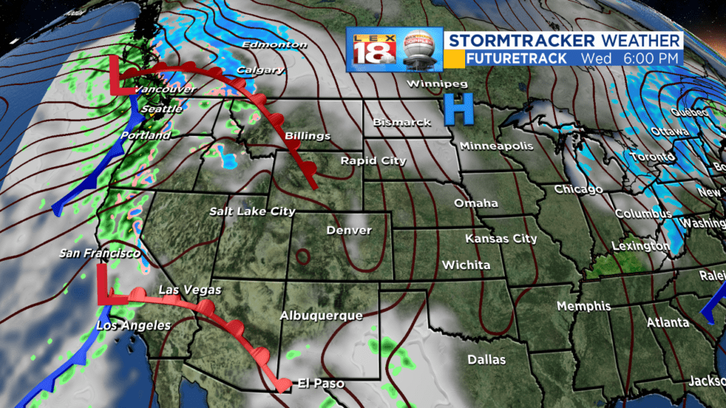
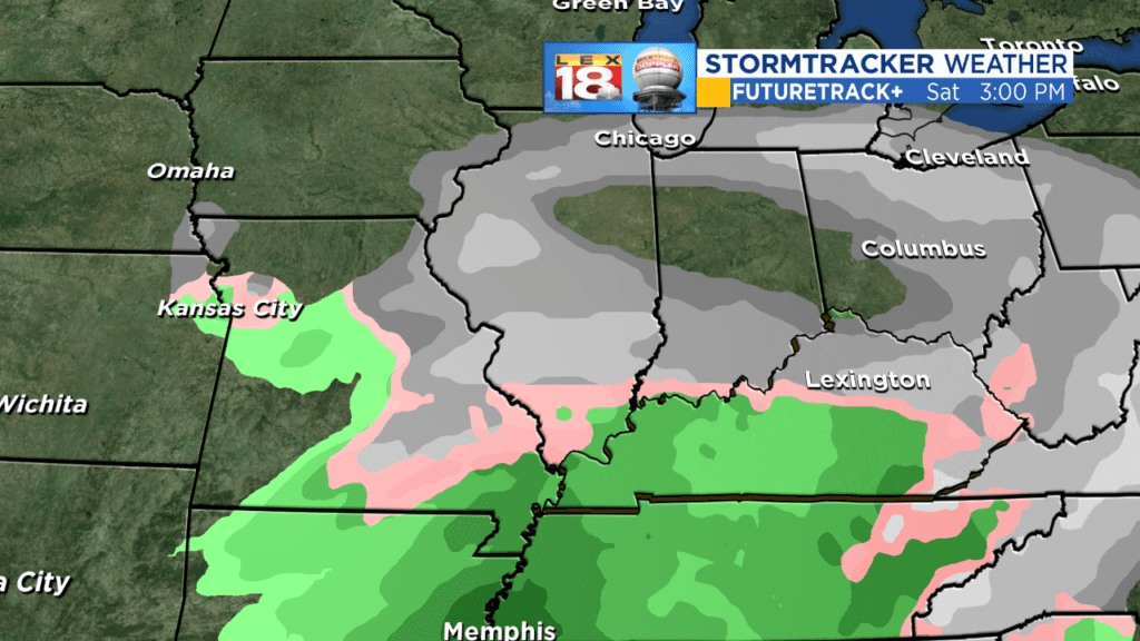
Now, here’s where life gets tricky, because all that really matters at this point to most folks is what is going to be in their backyard this weekend. Truthfully, there is no good answer yet. What’s likely to happen is those 2 lows will begin to dive into the cold trough that will be digging into the nation’s mid section. The cold high (the blue H) helps to outline the position. At some point, and we don’t know where yet, the 2 lows should begin to combine back into 1 in a process called phasing. At this point in time we could see that literally occur anywhere from the Ozarks to the Atlantic. If there were more snow to our north, the western solution would be more likely as lows like to run along boundries and it would dive southward toward the snow line. But with the lack of snow our northern low may just zip along and north of I-80 (remember the snow map from earlier), while the southern low parallels it with an eventual link up as some degree of noreaster in the Atlantic. As it is, the cold air looks marginal by the weekend if the lows stay apart and with a low in the southern stream, some mischief is possible as depicted by the European model.
The computer models are wonderful tools and at this range are terrific with ‘big picture’ items…we know there’s a storm out there…we know there’s going to be some cold air around. What they’re not particularly good at at this distance are the fine details which is what determines your backyard weather. There will likely be some wild solutions in the coming days. There already were some with the American model earlier today, but it backed off midday. Until the low gets into the dense data grid there are likely to be all kinds of crazy solutions and trust them at your own peril.
So this is your heads up that winter is indeed returning and our warm cycle looks to end. Now we’ll also see if the pattern of cycles of the past year+ continues, once the switch is flipped does it stay flipped, or is this just a transient cold shot. The European ensembles would argue it’s transient, but the overall pattern would argue otherwise…and now we’re talkng 10+ days out, which is what we delightfully call model fantasy-land. So we’ll focus on what’s in front of us.
Enjoy your final day of warmth until further notice. It will also be a windy day. And stay tuned as we approach the middle portion of the winter season. There’s a long way to go!
All the best…
Bill
