
You might have heard by now that there’s going to be some weather hijinks this weekend. It’s a pretty complicated scenario with lots of moving parts, but in several way it’s not all that atypical for bigger storms around here.
We’ve been talking about the potential for a southward drift to the overall scenario. That had been playing out in the computer modeling throughout the week and in fact last night’s Euro was a snow blast for us. It was a trend that had gone too far with the surface low all the way down in southern Tennessee.This is also why you don’t base a forecast off of a single model run, but look at overall trends and assess the players on the field.
There was great concern in the fabuous StormTracker Weather Center this afternoon. Essentially every model known to man was taking this monsterous storm and turning it into a ‘Cutter’…an area of low pressure that heads toward eastern Kentucky and then reforms on the other side of the Appalachians. This brings a slug of warm air with it, and that has always been our thought that southern Kentucky may end up pretty mild Saturday. In fact, the temperatures Saturday afternoon look like a forecasting nightmare. It’s always fun to see 20 degrees of difference between Richmond and Lexington out there in model-land.

With a great majority of our potential winter storms doing this, it’s a decent solution to begin to believe in. However, this northward shift was also sudden and new, so as a general rule you don’t want to jump boldly on it. The forecast thinking was to basically maintain the status quo and with that in mind we’ve put out our numbers. Trutfhully I’d prefer to wait for tonight’s Euro run, but that won’t be in until around 2:00 am, and I’m just not that good at staying up late any more. However the 0z run of the NAM has come in, and it’s solution is not far from our overall idea, so it adds a degree of confidence.
Here’s our bottom line from 36+ hours out from the onset. The vast majority of stuff that’s going to fall looks to be just plain rain. Now north of I-64 it may be a cold plain rain, but that’s also pretty typical. With that said, it may be cold enough at the beginning that a period of freezing rain or snow is possible, this again mainly across the north. As the day unfolds heavy rain will fall (you can wish it was snow, and there’s still some hope, but not much) and it will turn windy. I do like the warmer temps across the south, but not quite as warm as that model (RPM) depiction shows. We’re forecasting 46 in Lexington (up from 44 yesterday). There’s a chance that is too high, but that’s sort of a moot point as it’s above freezing regardless. As the day continues it’s windy and by late afternoon the temperatures will begin to crash. We’ll then see the changeover to snow, and it should happen pretty quickly. And with that, here’s our 2 day out snow forecast.
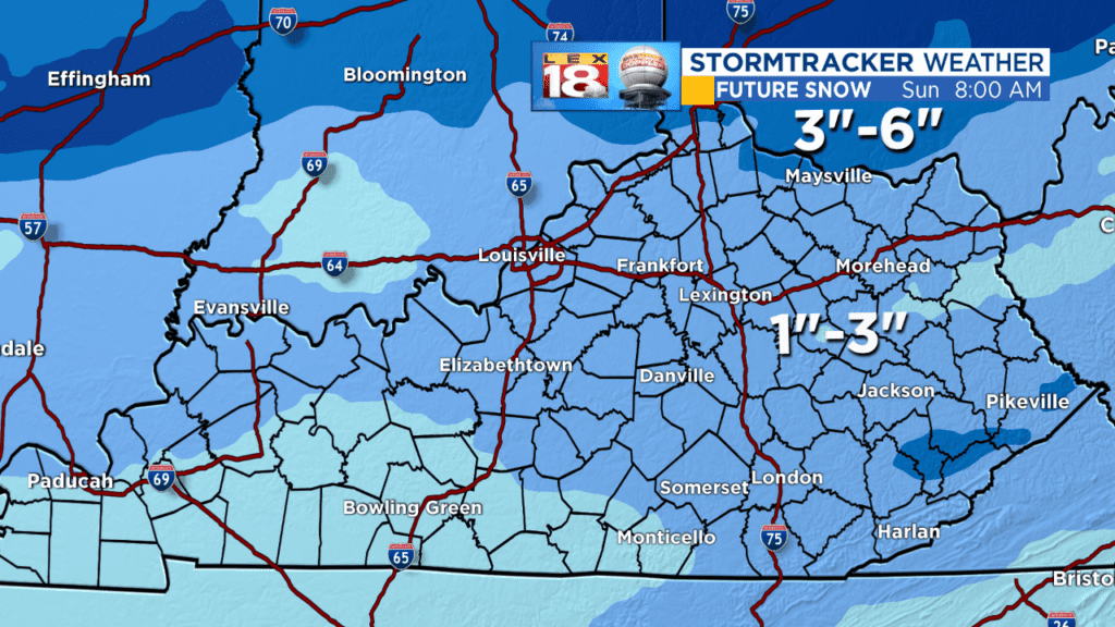
You will not wake up to snow Saturday morning (unless you’re well to the north). Saturday is mainly rain. Our snow accumulation looks to occur in the wrap around Saturday afternoon and evening and at this point we’re going with a general 1 to 3 inches. There’ll be much less snow around Lake Cumberland compared to near the Ohio River. In far northern Kentucky we’ve got 3-6 inches. Maysville to the Cinci metro. Now as close as Cincinnati this is going to be another BIG DEAL winter storm with 6 to 10 from the northern suburbs of Cinci north and east. It’s close to us, but at this point I don’t see the mechanism to bring it this far south. Remember this started as an I-70 storm, but the thought was it would drift toward the Ohio. That may still be a pretty good line of reasoning.
The Arctic front will help lay down some really impressive powder snow totals north of Indy, but its arrival is likely too late for us to get more than what we’ve depicted.
So you have our forecast, we’ve broadcast it and put it out there. Can it change? Of course, from this distance only a small deviation of the storm track for a storm which is currently in pieces thanks to the Rockies is certainly possible. We’ve given you what we think is the best solution, but if the storm does end up staying more toward Knoxville instead of toward Corbin, then move the cold air that much farther to the south and all of a sudden my stock in Kroger goes up ( 🙂 ). Say the storm comes 50 miles north, or reforms in the Oklahoma Panhandle as opposed to the Texas panhandle then the 50’s to around 60 seen above moves a corresponding bit north and puts rain just about to the Ohio and we could be talking about thunderstorms.
But again, you have our best thinking from 2 days out there. Most of our snow falls Saturday night. The wind will howl and the temperatures will plummet…the (cue ominous music) Flash Freeze. This is NOT a new phenomenon, much like the ‘Polar Vortex’, Super Moon, or this weekend’s Super Blood Moon marketing names for common things have come in to vogue. These sudden drops happen with Arctic fronts and they pass a few times each winter. What can you expect from the “Flash Freeze”? Well anything wet will ice up and likely dry up with time. If you leave your car out all day there’s a chance it will ice over and make getting in difficult. (it’s happened to me), and there will be icy spots on the roads. The heavy rain will make pretreating impossible.
By the way, with the Arctic air and snow cover where significant snow was looking to be around in model-land, Cincinnati was forecasted to about -10 Monday morning while us, with less snow expected will be between +5 and 10. Your pocket forecasting guide, the more snow on the ground, the colder Monday morning will be. Even with little snow, the ambient air gets us to, or just in, the single digits.
It’s not looking like a snow you in event, but it WILL GET VERY COLD. Wind chills will be about 10 degrees either side of 0 in to midday Monday.
We’ll update Friday and see how much, if any change, is needed to get you ready for winter this weekend. Hopefully this whole thing gives you insight to what we’re thinking.
Well what was supposed to be a quick post has turned in to a 11 hundred word extravaganza.
All the best…
Bill
