
Today was the day of the final call for this weekend’s RAIN and snow. We’ve done the work and there’s not much else that can be done at this end (although Seth may try to fine tune in the morning) as last night’s Euro run, today’s Euro run, and many of the short term hi res models converged toward the solution we had plotted out previously. It’s still not a sure thing, but it does add confidence to the overall forecast and that overall given the facts in hand that our thinking was in the right place.

Our forecast holds with a general 1 to 3 inches around the area. If you’re headed toward Cincinnati or the Ohio River in general, snow fall amounts will be higher (in fact just checked the new NAM run while I was typing this Friday evening and it’s plotting out 6″+ for the areas around Cincy now although I still like our general 3-6 there) with generally lesser amounts south and east. There are Snow/Winter Weather/Traveler’s Advisories up for the entire state (literally). It’s likely this will also be a tough snow to get an accurate measurement as it will be a highly wind driven snow with sustained wind in the 25-30 mph range with gusts pushing 40. There may end up being patches where the wind sweeps it nearly bare, and others where the wind can pile up tiny ‘drifts’. Your best bet is a wind shielded snow board and my guess is Ron up in Georgetown has one and perhaps a few other of the high end enthusiasts.
So here are your highlights…
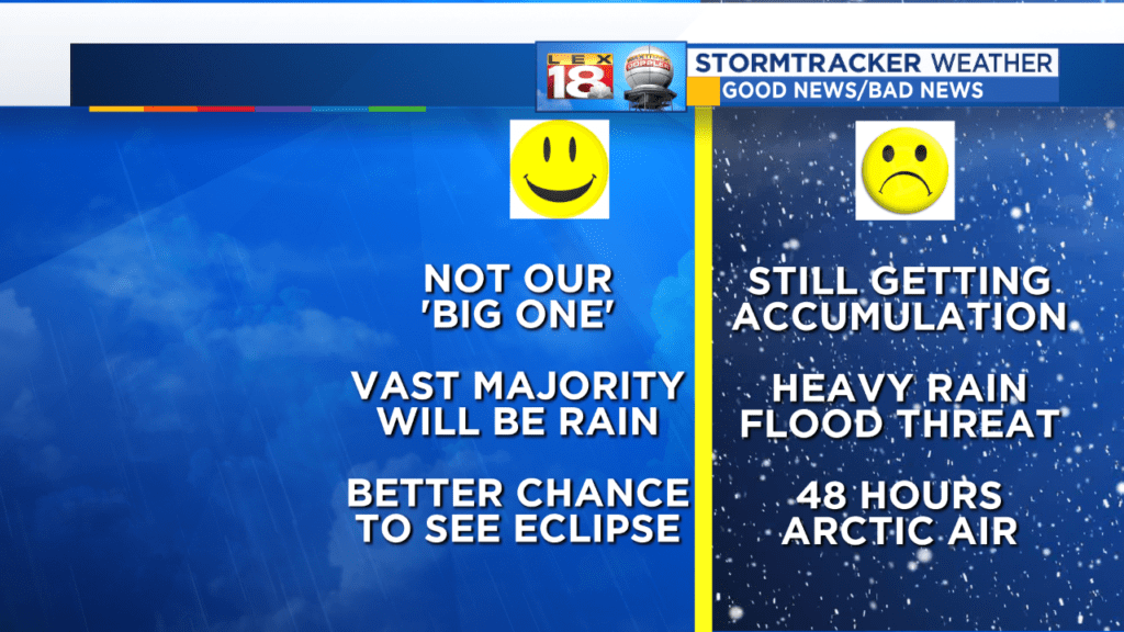
This is NOT our big storm. Yes, it’s going to snow and yes there will likely be accumulation, but this is more in the nuisance slow you down but not snow you in category (see above). By the way, many people would put the accumulation in the ‘Good News’ column. I just put it there because there will be hassles to deal with if you travel Saturday Night and Sunday Morning. After that, most places should be get aroundable. We’re expecting about a 4 to 6 hour burst of decent snow.
AGAIN…AGAIN…AGAIN this is almost all rain. We may pick up an inch and a half of rain (liquid equivalent), and maybe a 1/4 inch of that would be snow. There is a minor flood potential with this heavier rain. Again…this is almost all rain!
The Arctic blast lasts from late Saturday night until Monday night when we’ll transition out of the true Arctic air. Wind chills by Sunday morning should be zero and below. Sunday’s theremometer will move very little, even if the Sun comes out with highs in the low 20s and staying windy. The wind dies Sunday night as the Arctic lobe passes nearby. This is when the temperature can really bottom out where there’s a decent snow cover. If Cincy gets that 6″ of snow, they’re looking at maybe 10 below or colder Monday morning. I think here we’ll be somewhere in the neighborhood 0.
The overall pattern is winter until further notice. There may be brief milder interludes, but the prolonged cycle of days of above normal is over. In fact, and this is from the weather kicks and giggles department, the Day 9 Euro brings the Polar Vortex body and soul to Ohio. Also, this should be the only time social media uses that term since it would actually be here. Jill and I literally just giggled with delight seeing that because if, IF, something like that occurs, THAT is a rare meteorological event.

The Euro is by itself with that, but that’s almost like something weather folks would pay to see. Let’s see how the next few days handle it before we start getting all silly. What’s interesting is the other meteorology bits we’ve talked about recently. There’s the warm thumb going up toward Alaska (positive PNA), there’s ridging heading up toward Greenland (-NAO) and we get the toothpaste tube effect. The two warm ridges displace the Arctic Motherlode south by squeezing the tube.
It’s fun (no it’s amazing) to look at…This would be like pitching a perfect game, sinking a half courter to win a national championship, and making a 43 yard field goal to win a playoff game without doinking it off an upright (and a crossbar) all rolled up into one. Will this become part of real live actual forecasts next week? We’ll see as we’ve been talking about the pattern flip and this does fit into, but on steroids.
Until then we’ll deal with the rain, 25 degree shifts from north to south across the state Saturday afternoon, a late day/more likely evening change to a snow burst, tanking temperatures, brutal wind chills, and barbaric cold. You know I probably could have written that sentence at the top and saved 800 words.
Anyway, all the best to you…
Bill
