
Hello again boys and girls and welcome to another adventure in this wonderful thing we call The Weather. We’ve come to the end of another one of our meteorological ‘seasons’ and it’s always fun to look at these in historical perspective, especially when the ‘seasons’ are pretty doggone noteworthy.
As a reminder, and for those who always like to call/email and say, “it’s not the end of winter…”, when we talk about meteorological seasons we in the ol’ weather biz like to cut things off at the beginning and end of months. Plain and simple it just makes bookkeeping a whole lot easier. So on this Thursday, February 28, it’s the final day of Meteorological Winter…December 1 to February 28. Whatever happens weatherwise after this writing won’t significantly influence the overall stats for the season, so we don’t have to wait until midnight.
The bottom line is this was a very warm and very wet winter for us. You’ve already figured that out by the giant mud pit in your yard and the early spring flowers that are already blooming (and boy are they in for a rude awakening, but we’ll detail that in a bit). The magintude of the climatic variables puts this month into the historic category, but we’ll also offer some perspective with each of these.
First let’s talk temperatures. Aside from the glancing blow from the (cue ominous music) Polar Vortex at the end of January, we saw a lot of pretty mild days. Lexington never officially got below zero which isn’t all that unusual, but we did have that short shot of real cold. However, overall this was a very warm season.
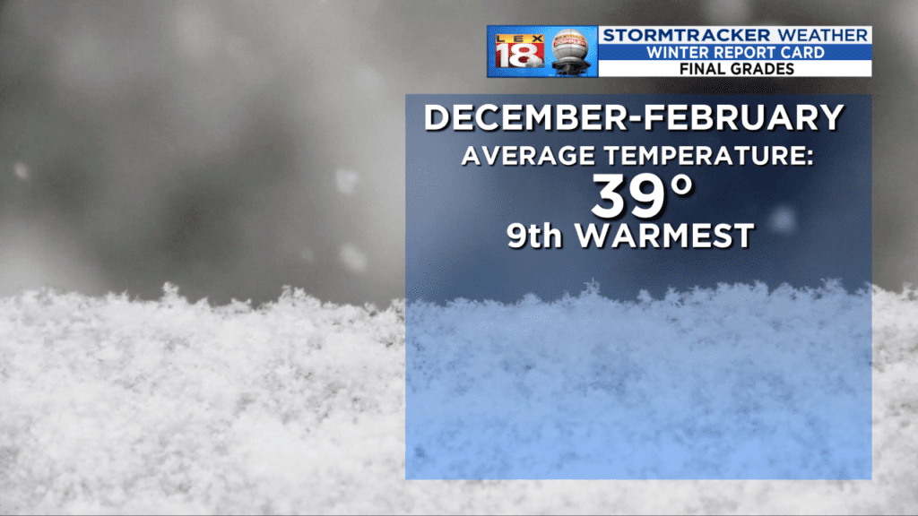
When you’re in the top 10, there’s no two ways around it, this was an historically warm winter. This is interesting from a couple of points. First off, 4 of the top 9 have occurred in the last decade. It’s in the climate record…it’s a fact. But before we start running to the hills remember that weather always works in cycles, it’s just some of them are very long cycles, like on the order of decades. We’ve done this before, but you have to go back to a 5 year period starting in 1948 where we also ended up with 3 of the warmest winters…and those are records that have stood for 70 years. From the Midwest Climate Center at the University of Illinois this is the climate record.
So with all of that history…let’s take a quick look at the future as we begin Meteorological Spring on Friday. It looks like we’ll be making up for some lost winter time as some true Arctic cold will be plunging south and the potential for a winter storm to be in the Ohio Valley Sunday. The earlier alluded to storm is getting ready to pummel the West Coast with another Pineapple Express. You can see the moisture feed coming from the tropical Pacific.

This will drop huge rains and epic mountain snows for them. The low will then begin to reorganize Saturday somewhere near the Texas panhandle. It will then eject out toward the Tennessee Valley with a ton of moisture both from the Pacific and the Gulf of Mexico involved. A pressing Arctic air mass will be changing the cold rain of Sunday over to snow. How quickly that happens will help determine the amounts, and from Thursday for a storm that’s just beginning to hit the West Coast it’s far too soon to go much beyond that. The significant snow chances do look much better on the other side of the Ohio, but it’s still interesting.

As that low departs, it’s going to yank down some pure Arctic air in its wake.

We’re looking at a couple of days next week…in MARCH…where we may not get above freezing. We didn’t do that often in January and with the high sun angle as we approach REAL spring, that’s saying something.
So you’re weekend has an interesting feel to it. Keep alert of our forecasts as this system unfolds. It’s another case where a few dozen miles may make all the difference. We’re targeting Sunday afternoon and evening as the critical times.
Hopefully you’ve also enjoyed the little bit of history in this piece. It’s been an amazing winter, but we’ve been here before. All we can hope is that we can start to dry out some as we enter spring. And wouldn’t it be nice to actually have a spring this year instead of the chill of last year (but on the flip side of that, it does keep severe weather down).
All the best…
Bill
