

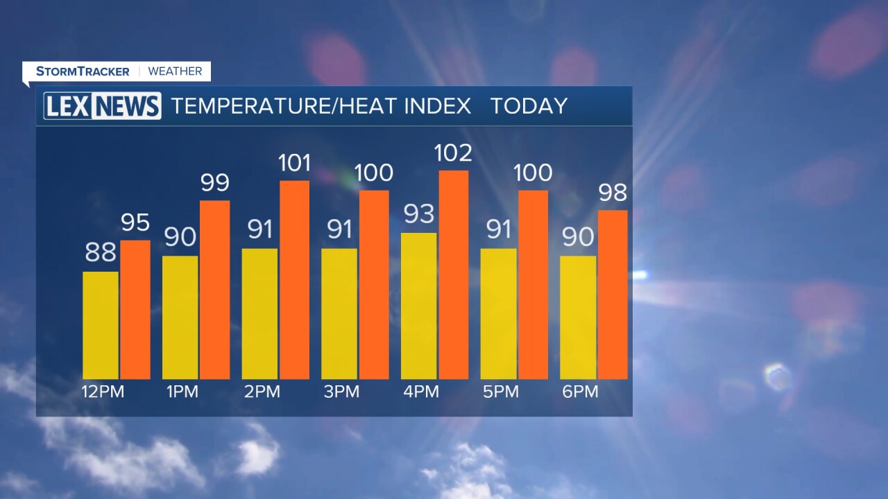


Another hot and humid afternoon
We started Sunday morning on another warm and muggy note, with temperatures generally in the low to mid 70s and some clouds hanging around the region.
Temperatures will quickly climb as we head through the morning and afternoon. Highs are expected to reach the low to mid 90s, but the humidity will make it feel even hotter.
Heat index values will climb above 100 degrees across much of the area, with some locations potentially feeling as hot as 105 to 109 degrees. A Heat Advisory remains in effect for Anderson and Russel counties through 9 p.m. EDT Sunday.
If you have outdoor plans, make sure you're drinking plenty of water, taking frequent breaks in the shade or air conditioning and limiting strenuous outdoor activities during the hottest part of the day.
Strong storms possible late Sunday
Along with the heat, we'll be watching for another round of showers and thunderstorms later Sunday.
Most of the region should stay dry through at least the first half of the day, allowing temperatures to quickly heat up. As a cold front begins approaching the region later this afternoon, isolated to scattered showers and thunderstorms will start to develop.
The Storm Prediction Center has placed areas around the I-64 corridor and farther north under a Level 2 out of 5, or Slight Risk, for severe thunderstorms. A Level 1 out of 5, or Marginal Risk, extends farther south and east into portions of Kentucky.
That doesn't mean we can let our guard down. Any stronger storm that develops could produce damaging wind gusts, very heavy rainfall and frequent lightning.
Heavy downpours could create isolated flooding
Along with the damaging wind threat, we'll also have to keep an eye on the potential for isolated flash flooding.
There is plenty of moisture available in the atmosphere, meaning thunderstorms will be capable of producing very heavy downpours over a short period of time.
Widespread flooding is not expected, but areas that receive a slower-moving storm or multiple rounds of heavy rainfall could experience localized flooding problems.
Storms linger into Monday
Showers and thunderstorms will remain possible Sunday night as the cold front slowly pushes south across Kentucky.
Temperatures will remain warm and muggy overnight, and additional showers and storms could continue into the early morning hours Monday.
Monday currently looks like our best opportunity for more widespread shower and thunderstorm activity this week as the front continues moving through the region. A few showers and storms could linger into the afternoon, especially farther south.
Cooler and more comfortable air arrives
Once the cold front finally clears the region Monday evening, we'll begin to notice a significant change.
High pressure will settle in behind the front, allowing drier and less humid air to move into Central and Eastern Kentucky. By Tuesday, dew points will fall into the 60s, making it feel much more comfortable outside.
Tuesday should be mainly dry with plenty of sunshine. Afternoon highs are expected to reach the upper 80s, but the lower humidity will make a big difference compared to the oppressive conditions we've experienced this weekend.
Tuesday night will also feel more comfortable, with temperatures falling into the mid to upper 60s.
Rain chances return later in the week
Another disturbance will approach the region Wednesday afternoon, bringing shower and thunderstorm chances back into the forecast. Additional rounds of scattered showers and storms will then remain possible Thursday and Friday.
The increased clouds and rain chances will help keep temperatures in check. After highs in the upper 80s to around 90 Wednesday, temperatures should settle into the low to mid 80s for the second half of the week.
