



We are starting off this Sunday with mostly clear skies across much of the area, while a few clouds and lingering showers are hanging around parts of southern Kentucky. Any showers we are seeing this morning should gradually clear out, leaving us with plenty of sunshine, heat and humidity for the rest of the day.
The quieter weather will stick around through the beginning of the new workweek, but changes are on the horizon. Shower and thunderstorm chances will begin increasing as we head deeper into the week, with multiple rounds of storms potentially bringing heavy rainfall to parts of Kentucky.
Mostly Sunny, Hot and Humid Sunday
Once we get rid of the lingering clouds and showers across southern Kentucky this morning, most of us are looking at a dry and mostly sunny afternoon.
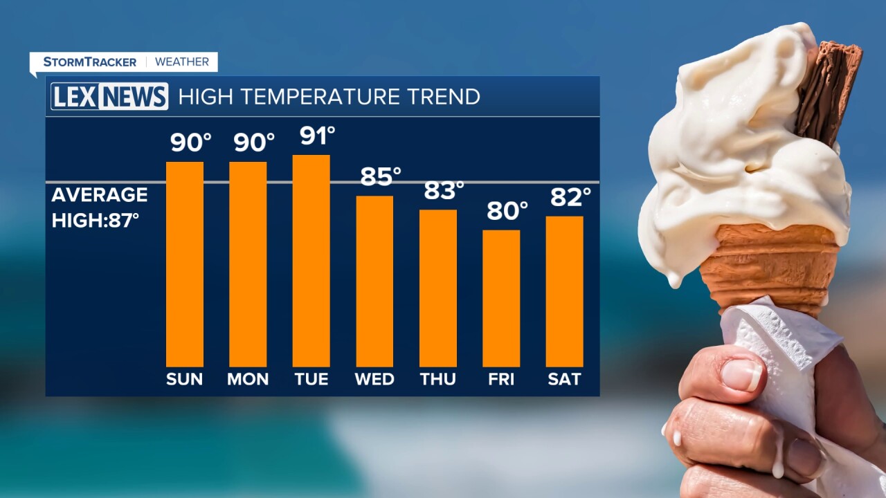
Temperatures will quickly warm through the 80s before reaching the upper 80s and lower 90s this afternoon. Add in plenty of humidity, with dew points in the lower to middle 70s, and it will feel even hotter. Heat index values are expected to reach the middle and upper 90s for many of us during the hottest part of the day.
There is still a very isolated chance for a shower or thunderstorm across southern Kentucky this afternoon and evening, but most of us should stay dry.
If you have outdoor plans, make sure you are keeping the heat in mind. Drink plenty of water, take breaks when needed and try to limit strenuous outdoor activities during the hottest part of the afternoon.
It will remain warm and muggy, though, with overnight temperatures only dropping into the lower 70s by Monday morning.
Heat Sticks Around Monday
Monday will bring another hot and humid afternoon across central and eastern Kentucky. Most of the day should stay dry with partly to mostly sunny skies and afternoon temperatures climbing back into the lower 90s.
Heat index values will once again climb into the middle and upper 90s, with a few locations potentially getting close to 100 degrees.
By late Monday afternoon and evening, we will begin watching for the possibility of thunderstorms approaching from the northwest. The best chance initially looks to be in parts of northern Kentucky
Storm Chances Increase By Midweek
Tuesday will bring another warm day, with afternoon temperatures ranging from the upper 80s to lower 90s. However, our overall weather pattern will begin changing as we head deeper into the week.
A northwest flow will develop across the Ohio Valley, allowing several disturbances to move toward our region. Each one could spark clusters of showers and thunderstorms, with the storm track gradually shifting farther south into Kentucky as the week progresses.
The highest rain and storm chances currently look to arrive from Wednesday through Friday.
With plenty of heat and moisture available, some of these storms could become stronger. Damaging wind gusts, frequent lightning and torrential rainfall would be the primary concerns with any stronger storms.
Heavy Rain Could Become a Concern
Along with the potential for stronger storms, we will also have to watch the amount of rainfall we pick up during the middle and latter portions of the week.
Multiple rounds of thunderstorms could move over some of the same locations, creating the potential for excessive rainfall and localized flash flooding. Current indications place the greater concern across portions of central and eastern Kentucky.
Rainfall totals could reach around 1 to 2.5 inches or more in some locations over the course of the unsettled pattern, but exactly where the heaviest totals set up will depend heavily on the tracks of individual clusters of thunderstorms.
Cooler Temperatures With More Clouds and Rain
The additional clouds, showers and thunderstorms should help knock temperatures down a little later in the week.
After highs in the upper 80s and lower 90s Tuesday and Wednesday, temperatures should trend back into the 80s Thursday through Saturday.
It will still feel like summer, but the increase in clouds and rainfall should at least provide some relief from the lower 90s expected through the beginning of the week.
