

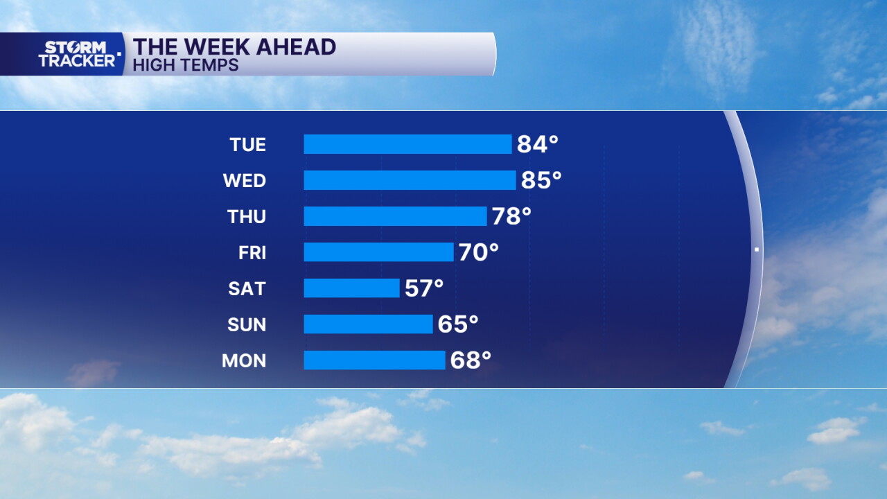


After a gloomy and rainy weekend, sunshine has finally made a welcome return across Central and Eastern Kentucky this Monday afternoon! Most of the clouds from earlier this morning have cleared out, leaving us with a mixture of sunshine and a few lingering clouds.
Temperatures have also rebounded nicely into the upper 70s and low 80s, making for a beautiful afternoon across the area. However, we're about to see quite the temperature swing over the next several days, with near-record warmth followed by a significant fall cooldown heading into the weekend.
Near-record warmth Tuesday and Wednesday
It's going to feel more like the middle of summer than the middle of October over the next couple of days!
Temperatures will climb into the mid 80s Tuesday afternoon, potentially approaching record highs in some locations. We'll also notice humidity increasing as warmer, more moisture-rich air moves into the region.
Wednesday will remain very warm, with highs generally reaching the mid to upper 80s. However, increasing cloud cover and the approach of our next weather system could keep temperatures a little cooler than Tuesday.
Showers and storms return midweek
Our next chance for rain arrives late Tuesday night into Wednesday as a slow-moving cold front approaches the Ohio Valley.
We'll see isolated to scattered showers and thunderstorms Wednesday into Thursday, with periods of heavy rainfall possible in some locations.
The overall severe-weather threat remains low, but a few stronger storms could produce gusty winds and locally heavy downpours.
Most locations could pick up around a quarter to three-quarters of an inch of rain, although some areas could receive more depending on where the heaviest showers develop.
Big temperature drop arrives Friday
By Friday, the cold front should finally push through the region, bringing much cooler and drier air into Kentucky.
Rain chances will begin winding down, with Friday looking mostly dry. Afternoon highs will only reach the upper 60s to low 70s across much of Central and Eastern Kentucky, with even cooler temperatures farther north.
That's going to feel like a big change compared to the near-90-degree temperatures earlier in the week!
Chilly weekend with first frost possible
The coolest air of the season so far looks to arrive just in time for the weekend.
Saturday afternoon highs could struggle to get out of the upper 50s and low 60s, making it feel much more like fall across the region.
The bigger story may be Saturday night into Sunday morning, when temperatures could fall into the 30s across portions of Central and Eastern Kentucky.
That could bring our first frost of the season to some locations, especially our typically colder valleys and rural areas.
The good news is that dry weather should stick around through the weekend, giving us a chance to enjoy some cooler fall weather after the summer-like warmth earlier in the week.
 Facebook
  TikTok
  YouTube
 Instagram
 Threads
 X
X