



We are starting off Saturday morning with areas of dense fog across Central and Eastern Kentucky. Visibility has dropped to around a half-mile in some locations and all the way down to near zero in a few spots, so make sure to slow down and use extra caution if you're heading out early this morning.
It is also a warm and muggy start, with temperatures in the upper 60s and low 70s. We are dry for now after showers and storms moved out late last night and early this morning, but another round of storms will be possible later today.
Fog Clears With Another Hot Afternoon Ahead
The dense fog should gradually improve as we go throughout the morning, with mostly dry conditions continuing into the early afternoon.
Once the fog clears, temperatures will quickly climb. Afternoon highs are expected to reach the 90s across much of the area, with plenty of humidity making it feel even hotter.
Storms Develop Later This Afternoon
Our attention then turns to another round of scattered showers and thunderstorms developing later this afternoon and continuing into the evening.
Rain chances will be highest across Northern and Northeastern Kentucky, although isolated storms will also be possible farther south. Not everyone will see rain, but those who do could experience a quick burst of heavy rainfall, frequent lightning and gusty winds.
There is a Level 1 out of 5 risk for severe weather across the area, with damaging wind gusts being the main concern. A few of the strongest storms could produce wind gusts around 40 to 60 mph, along with locally heavy rainfall.
Storm coverage should gradually decrease later tonight as activity pushes out of the area.
Another Hot Day Sunday
We'll dry things out again heading into Sunday morning before essentially repeating a similar pattern.
Sunday will bring another hot afternoon, with temperatures once again climbing into the 90s. Humidity may come down slightly in some areas, but it will still feel very warm outside.
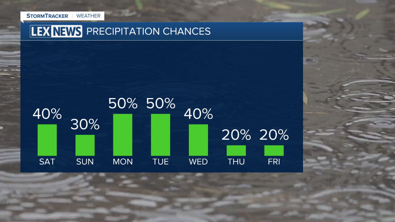
A stray shower or thunderstorm will once again be possible during the afternoon and evening, particularly near and north of I-64. The overall chance for rain will be lower than Saturday, but any stronger storm could still produce locally gusty winds.
Better Rain Chances Arrive Monday and Tuesday
The weather pattern finally begins to change as we start the new workweek.
A system moving through the region will bring a better chance for showers and thunderstorms Monday into Tuesday. Rain chances increase during this period, although the exact timing of the front will play a big role in Monday's temperatures.
Some locations could still climb well into the 80s or even low 90s Monday, while areas that see the front and rain earlier could stay much cooler.
Fall-Like Weather Finally Arrives
A noticeable cooldown will begin Tuesday as cooler and drier air works into the region.
Highs Tuesday should range from the 70s farther north to the low and mid 80s farther south. By Wednesday and for the remainder of the week, afternoon highs are expected to stay mainly in the 70s, with overnight lows dropping into the 50s.
That means much more seasonable, fall-like weather is on the way, with dry conditions expected to settle in for the second half of the week.
 Facebook
  TikTok
  YouTube
 Instagram
 Threads
 X
X