



We had another active day across Central and Eastern Kentucky Saturday, with scattered showers and thunderstorms developing throughout the afternoon. Some of these storms produced heavy rainfall and plenty of lightning, but activity is finally beginning to wind down as we head through the evening.
A few isolated showers and storms will continue to linger, especially across the Bluegrass and farther east, before most of the rain comes to an end later tonight. A Flood Watch also remains in effect for portions of Northeastern Kentucky through 1 a.m. Sunday.
Showers and Storms Wind Down Tonight
A few isolated to scattered showers and thunderstorms will remain possible through the evening, but coverage should steadily decrease after around 10 p.m.
Heavy rainfall and lightning will remain the main concerns with any lingering storms. Once the rain moves out, skies should gradually clear with overnight temperatures falling into the mid 60s to low 70s.
Patchy fog could also develop late tonight into early Sunday morning, especially in areas that received rainfall Saturday. Some of that fog could become locally dense in sheltered valleys, so give yourself a little extra time if you're heading out early Sunday.
Warmer and More Humid Sunday
Sunday will bring a much drier start to the day with more sunshine returning, but temperatures will quickly climb.
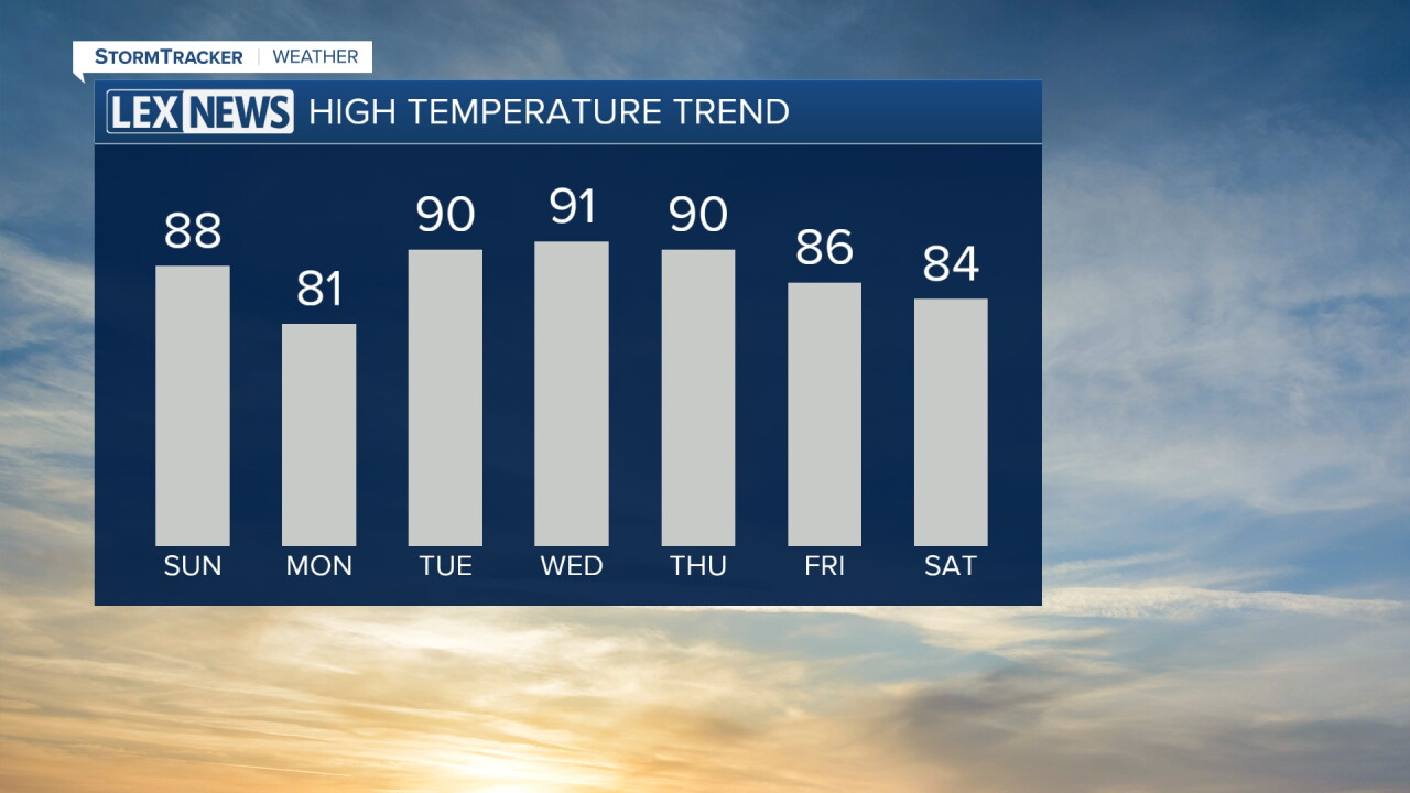
Afternoon highs are expected to reach the upper 80s and even low 90s in some locations. Humidity will also remain elevated, so it will feel warmer and muggier compared to what we experienced earlier in the week.
Most of the area should remain dry, but a few isolated showers or thunderstorms could develop Sunday afternoon, especially along and north of I-64 as another weak cold front approaches.
Slightly Cooler Monday
That front will gradually move south through the region Sunday night into Monday, bringing in slightly cooler and drier air.
Monday's temperatures will vary across the area, with highs closer to 80 degrees across the Bluegrass and warmer conditions into the mid and upper 80s closer to the Tennessee border.
Any lingering rain chances should remain limited before high pressure begins taking control of our weather.
Summer-like Heat Returns Midweek
Temperatures will quickly climb again Tuesday as a strong ridge of high pressure builds over the region.
Highs are expected to reach the low to mid 90s Tuesday through at least Thursday, which is well above normal for the middle of September. Humidity will increase as well, potentially pushing heat index values into the upper 90s and low 100s.
Tuesday and Wednesday should remain mostly dry with plenty of sunshine, making the heat the main weather story through the middle of the week.
Watching for Changes Late Next Week
There is more uncertainty as we head toward Thursday and Friday.
If the ridge of high pressure remains strong, the hot and mostly dry weather could stick around longer. If it begins weakening sooner, shower and thunderstorm chances could gradually return along with slightly cooler temperatures.
Our next better opportunity for rain currently looks more likely as we head toward next weekend with another cold front potentially approaching the Ohio Valley.
