

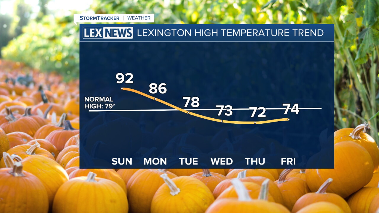


We are starting off warm and muggy across Central and Eastern Kentucky this Sunday morning, with temperatures in the upper 60s and low 70s.
Most of us should stay dry throughout the morning and into the early afternoon before a few isolated showers and thunderstorms become possible later today. Meanwhile, another hot September afternoon is ahead before a much more noticeable change in temperatures arrives this week.
Another Hot Sunday Ahead
Temperatures will quickly warm once again today, with afternoon highs reaching well into the 90s for much of the area.
Humidity should come down slightly compared to Saturday, but it will still feel very warm. Heat index values could approach 100 degrees in some locations, especially farther west.
Most communities should remain dry through the afternoon. However, an isolated shower or thunderstorm could pop up later in the day, with slightly better chances across Eastern Kentucky.
Storm Chances Increase Tonight
Another round of showers and thunderstorms could develop this evening and overnight, particularly near and north of I-64.
Most storms should remain below severe limits, but an isolated stronger storm can't be ruled out. Gusty winds would be the main concern, along with locally heavy rainfall and lightning.
Storm chances could linger into early Monday morning before the focus gradually shifts farther south and east.
Watching Another Round Monday
A cold front will begin pushing through the region Monday, bringing another opportunity for scattered showers and thunderstorms.
The best chance for storms during the afternoon and evening will be across the Bluegrass and Southern Kentucky, with some areas potentially staying dry altogether. A few stronger storms will be possible, with locally gusty winds and heavy rainfall being the main concerns.
The front will also create a pretty noticeable temperature difference across the region. Areas farther north may struggle to reach 80 degrees, while Southern Kentucky could still climb well into the 80s or even approach 90.
Fall Officially Arrives With Cooler Air
A much more noticeable cooldown begins Tuesday as cooler and drier air settles into the region.
Tuesday also marks the official beginning of fall, and the weather will certainly start feeling more like it. Most locations should see afternoon highs in the 70s, although parts of Southern Kentucky could still reach the low 80s.
Humidity will also drop, making it feel much more comfortable compared to the hot and muggy weather we've experienced recently.
70s Stick Around Through the Rest of the Week
The cooler weather isn't expected to be short-lived.
Wednesday and beyond, afternoon highs should remain mainly in the 70s across the area, while overnight temperatures drop into the 50s. Those temperatures are much closer to what we would normally expect for late September.
Once the early-week front clears the region, dry weather is also expected to settle in for the remainder of the week, giving us a much quieter and more fall-like stretch of weather.
 Facebook
  TikTok
  YouTube
 Instagram
 Threads
 X
X