

(LEX 18) — Closeness brings clarity, and if that isn’t on a Hallmark card, it should be. We’re now in the middle of the week continuing to track what looks to be a pretty memorable MLK weekend storm for someone. It just MAY not be us.
So here are some of the items that are coming into focus as we get closer to the weekend. There does look to be a significant winter storm moving across the South to the Eastern Seaboard. There are a lot of places that will get a lot of snow. It’s now looking like Saturday until Monday for the storm in total, and the impacts for us look to be late Saturday into late Sunday or early Monday. These are some of the broad-brush items that will eventually lead us to the details, which is your backyard. As we’ve talked about before, and we’ll mention again, details are simply impossible at this distance in time.
Again, we’re talking about some of the puzzle pieces beginning to fall into place. There’s some good agreement on the initial track dropping out of western Canada and dropping all the way down toward the Gulf Coast states. It will produce a good swath of snow across the Midwest and Plains as it dives southeast. Where it makes the turn, which will be somewhere around Mississippi, and how sharp a turn determines how our weekend evolves.
There are now 2 schools of thought with this. On the accompanying map, we have the first labeled Track 1 (yeah, we’re pretty original). This is what we call a ‘Cutter’. It’s where the surface low makes a sharp turn and follows an inverted trough along the WEST side of the Appalachians. This is the track that happens for us more often than this snow lover would like to think about. It’s the climatologically favored track, especially for a stronger initial low. In that scenario, there will be good dumping of snow well north and west of the actual storm track. However, and this is the forecasting nightmare, it also brings just enough warm air with it that we transition to areas of ice/wintry mix and just plain cold rain along and south of that track. Where those transition lines happen are the most difficult thing we forecast because a few miles can make a huge difference. Those lows then jump the mountains and reform off the Carolinas or Virginia and bring them a nice Nor’Easter. At this juncture, this is the solution being provided by the American model (GFS), and the Canadian model.
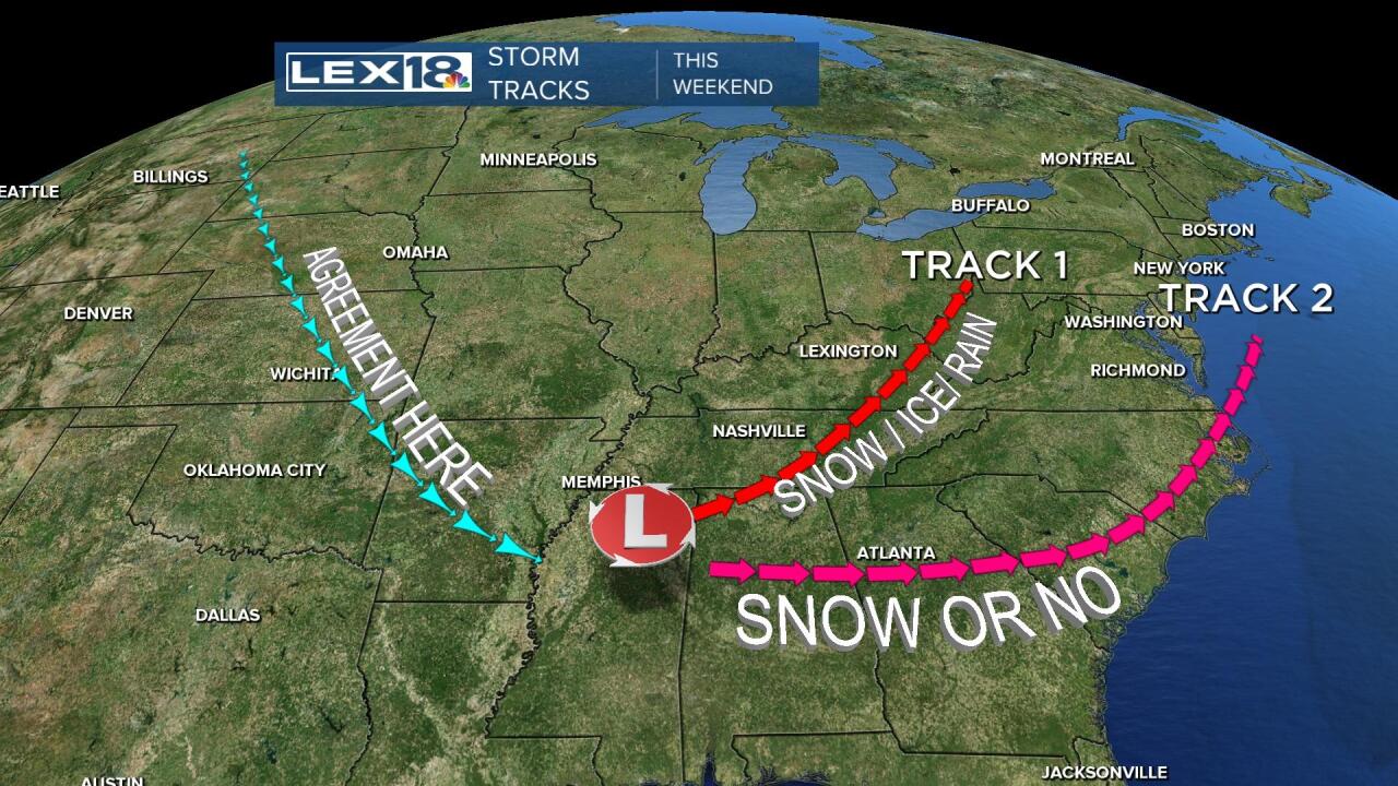
Track 2 is being favored, and consistently, by the European model. It takes the low on a complete southern track scooting around the base of the Appalachians before heading to the Outer Banks and also generating a Nor’Easter. It’s a path that can happen, but, more often than not it’s the one snow lovers hope for but ends up disappointing in the end. On that path, it’s either snow or no. It can bring a good snow to our area, especially eastern Kentucky. Since we’re on the northern edge of this if it goes too far south we watch the accumulating snow pass through Tennessee and the Carolinas and we’ll get nothing and like it (thank you Judge Smails).
The take-away for today’s piece. Yes, there is going to be a big storm somewhere nearby this weekend. Yes, we can still be impacted by said storm. But, we’re still about 4 days out…an eternity with snow forecasts. We should get a good idea by tomorrow if we’re on Track 1 or 2 and then begin to hammer out some more details.
What do you need to do at this point? Keep watching and keep informed as we continue to draw closer to yet another shot at winter.
