

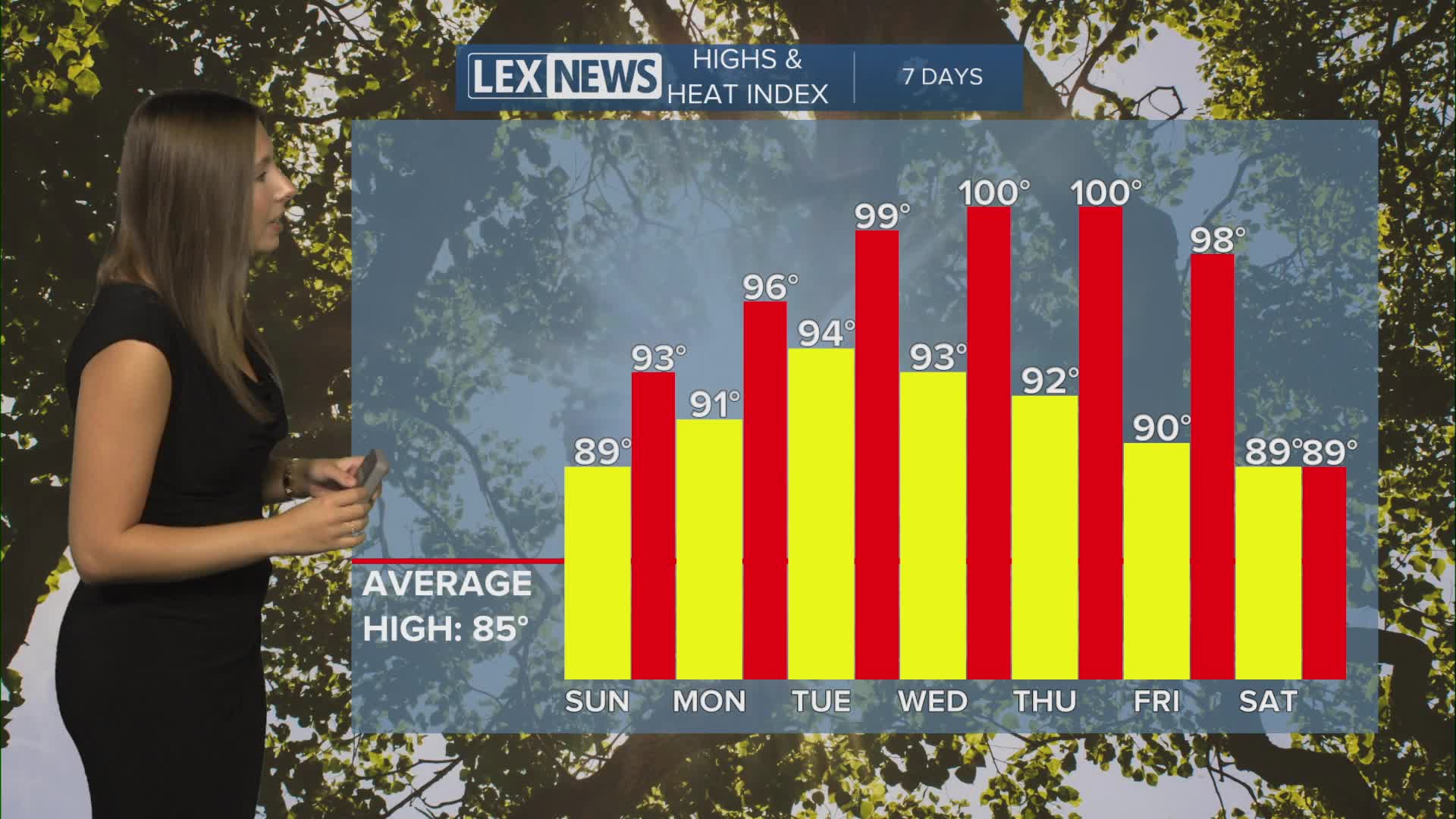


We are starting off our Saturday on another quiet note across Central and Eastern Kentucky, and that dry weather is going to stick with us through the weekend. The bigger weather story will quickly become the heat as temperatures climb into the 90s next week, with some of the hottest weather we've experienced recently possible by the middle of the week.
Sunny and warmer Saturday
We are starting Saturday morning mostly clear, with temperatures generally in the low to mid 60s across the area. A little valley fog is possible early this morning, but any fog that develops should quickly burn off after sunrise.
From there, expect another beautiful day with plenty of sunshine. Temperatures will warm into the upper 80s for most of us this afternoon, with a few locations, especially farther south, potentially reaching the low 90s.
Tonight will remain mostly clear and dry, but it won't be quite as cool as some of our recent nights. Overnight temperatures will only fall into the upper 60s.
Another hot and sunny day Sunday
Sunday will pretty much be a copy and paste of Saturday, with lots of sunshine and dry conditions sticking around.
Temperatures will once again reach the upper 80s to low 90s during the afternoon. High pressure remains firmly in control, which means we don't have to worry about any rain interrupting weekend plans.
Heat builds next week
The heat really starts to become the main story as we head into the new workweek.
Temperatures will climb solidly into the low 90s early in the week before potentially reaching the mid 90s in some locations by Tuesday and Wednesday.
Humidity will also increase, pushing heat index values into the upper 90s and potentially around or slightly above 100 degrees at times.
Another concern will be the duration of the heat. Overnight lows will only fall into the 70s next week, meaning there won't be much relief after sunset. With several consecutive hot days expected, make sure you're staying hydrated and taking breaks from the heat, especially if you're spending extended periods outside.
Watching for late-week rain chances
Our prolonged stretch of dry weather looks to continue through at least Wednesday.
By Thursday and into the second half of the week, we could finally introduce a few isolated showers and thunderstorms back into the forecast. Confidence remains fairly low on exactly how widespread those rain chances will become, so we'll continue to fine-tune that forecast over the next several days.
Even with those rain chances, temperatures could remain around 90 degrees or higher through the end of the week.
